Scientists have potentially narrowed the search area for the missing Malaysian airliner to three specific locations in the southern Indian Ocean, through new satellite and drift analysis of the 2014 crash released Wednesday.
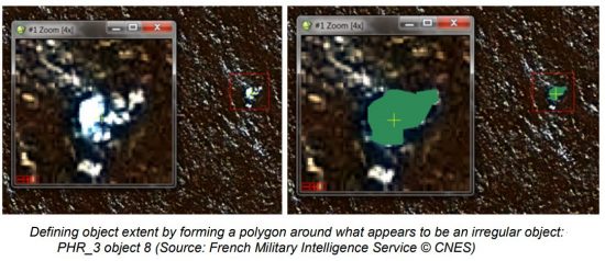
The new analysis is based on French military satellite images gathered on March 23, 2014 — two weeks after Flight 370 mysteriously veered far off course during a flight by Kuala Lumpur, Malaysia, to Beijing and were taken near the original underwater search zone.
The Australian bureau took over the search for Flight 370 from Malaysia a week later. Satellite experts at Geoscience Australia were not asked to analyze the images until March this year. The experts concluded that a dozen objects appeared to be man-made.
The CSIRO then investigated where the objects might have originated before drifting for two weeks. The CSIRO identified three potential crash sites:
- 35.6 degrees S, 92.8 degrees E
- 34.7 degrees S, 92.6 degrees E
- 35.3 degrees S, 91.8 degrees E
“So that is a way of potentially narrowing down the search area with the very important caveat that, of course, we can’t be totally sure that those objects seen in the images are actual pieces of plane,” CSIRO oceanographer David Griffin said.
“This might be a really good clue. It might be a red herring. But if you are going to search, then you’d be silly to ignore this potential clue,” he added.
But the Australian Transport Safety Bureau cautioned that the drift analysis by Australian science agency CSIRO is based on French satellite images of “probably man-made” floating objects without evidence that they were from Malaysia Airlines Flight 370.
